
Chapter 13
Aviation Weather Services
Inflight weather advisories, which are provided to en route aircraft, are forecasts that detail potentially hazardous weather. These advisories are also available to pilots prior to departure for flight planning purposes. An inflight weather advisory is issued in the form of either an AIRMET, SIGMET, or convective SIGMET.
AIRMET
AIRMETs (WAs) are examples of inflight weather advisories that are issued every 6 hours with intermediate updates issued as needed for a particular area forecast region. The information contained in an AIRMET is of operational interest to all aircraft, but the weather section concerns phenomena considered potentially hazardous to light aircraft and aircraft with limited operational capabilities.
An AIRMET includes forecast of moderate icing, moderate turbulence, sustained surface winds of 30 knots or greater, widespread areas of ceilings less than 1,000 feet and/or visibilities less than three miles, and extensive mountain obscurement.
Each AIRMET bulletin has a fixed alphanumeric designator, numbered sequentially for easy identification, beginning with the first issuance of the day. Sierra is the AIRMET code used to denote IFR and mountain obscuration; Tango is used to denote turbulence, strong surface winds, and low-level wind shear; and Zulu is used to denote icing and freezing levels.
Example: BOSS WA 211945 AIRMET SIERRA UPDT 3 FOR IFR AND MTN OBSCN VALID UNTIL 220200 AIRMET IFT…ME NH VT MA CT RI NY NJ AND CSTL WTRS FROM CAR TO YSJ TO 150E ACK TO EWR TO YOW TO CAR OCNL CIG BLW 010/VIS BLW 3SM PCPN/BR. CONDS CONT BYD 02Z THRU 08Z
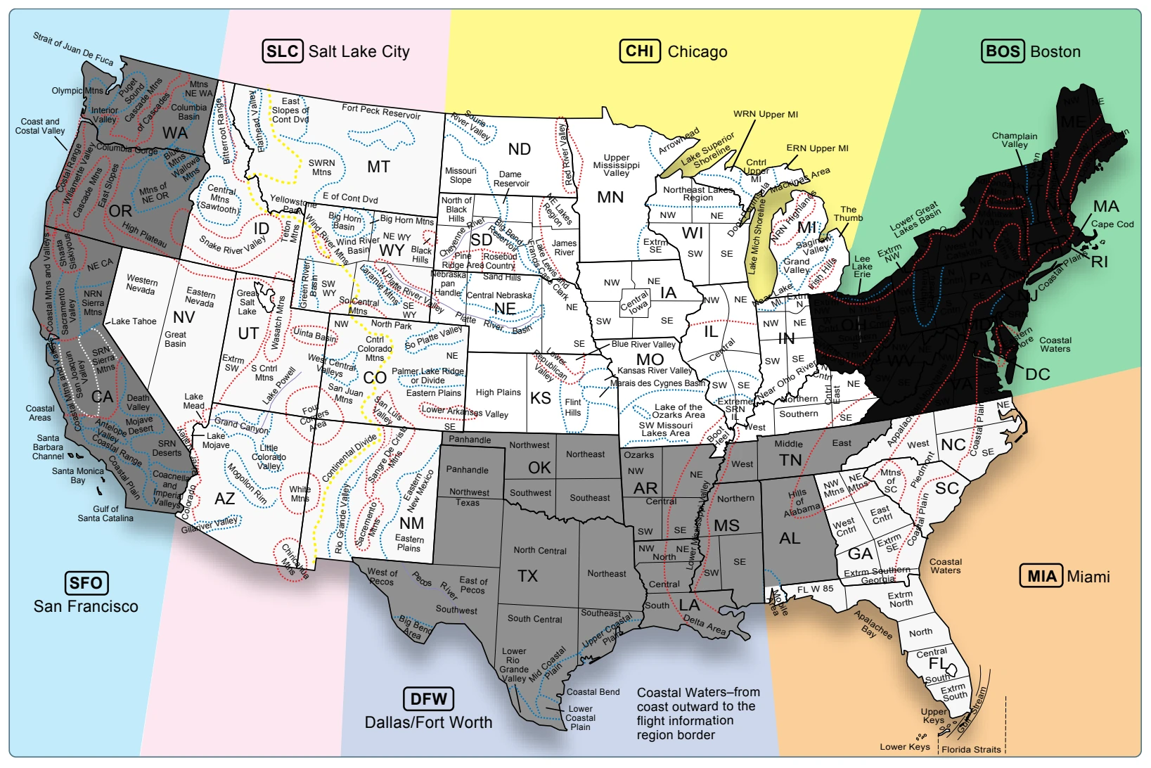
AIRMET MTN OBSCN…ME NH VT MA NY PA FROM CAR TO MLT TO CON TO SLT TO SYR TO CAR MTNS OCNLY OBSCD BY CLDS/PCPN/BR. CONDS CONT BYD 02Z THRU 08Z
Explanation: AIRMET SIERRA was issued for the Boston area at 1945Z on the 21st day of the month. SIERRA contains information on IFR and/or mountain obscurations. This is the third updated issuance of this Boston AIRMET series as indicated by “SIERRA UPDT 3” and is valid until 0200Z on the 22nd. The affected states within the BOS area are: Maine, New Hampshire, Vermont, Massachusetts, New York, and Pennsylvania. Within an area bounded by: Caribou, ME; to Saint Johns, New Brunswick; to 150 nautical miles east of Nantucket, MA; to Newark, NJ; to Ottawa, Ontario; to Caribou, ME. The effected states within Caribou, ME to Millinocket, ME to Concord, NH to Slate Run, PA to Syracuse, NY to Caribou, ME will experience ceilings below 1,000 feet/visibility below 3 SM, precipitation/mist. Conditions will continue beyond 0200Z through 0800Z.
SIGMET
SIGMETs (WSs) are inflight advisories concerning non-convective weather that is potentially hazardous to all aircraft. They report weather forecasts that include severe icing not associated with thunderstorms, severe or extreme turbulence or clear air turbulence (CAT) not associated with thunderstorms, dust storms or sandstorms that lower surface or inflight visibilities to below three miles, and volcanic ash. SIGMETs are unscheduled forecasts that are valid for 4 hours unless the SIGMET relates to a hurricane, in which case it is valid for 6 hours.
A SIGMET is issued under an alphabetic identifier, from November through Yankee. The first issuance of a SIGMET is designated as an Urgent Weather SIGMET (UWS). Reissued SIGMETs for the same weather phenomenon are sequentially numbered until the weather phenomenon ends.
Example: SFOR WS 100130 SIGMET ROME02 VALID UNTIL 100530 OR WA FROM SEA TO PDT TO EUG TO SEA OCNL SEV CAT BTN FL280 AND FL350 EXPCD DUE TO JTSTR. CONDS BGNG AFT 0200Z CONTG BYD 0530Z.
Explanation: This is SIGMET Romeo 2, the second issuance for this weather phenomenon. It is valid until the 10th day of the month at 0530Z time. This SIGMET is for Oregon and Washington, for a defined area from Seattle to Portland to Eugene to Seattle. It calls for occasional severe clear air turbulence between FL280 and FL350 due to the location of the jet stream. These conditions will begin after 0200Z and continue beyond the forecast scope of this SIGMET of 0530Z.
Convective Significant Meteorological Information (WST)
A Convective SIGMET (WST) is an inflight weather advisory issued for hazardous convective weather that affects the safety of every flight. Convective SIGMETs are issued for severe thunderstorms with surface winds greater than 50 knots, hail at the surface greater than or equal to ¾ inch in diameter, or tornadoes. They are also issued to advise pilots of embedded thunderstorms, lines of thunderstorms, or thunderstorms with heavy or greater precipitation that affect 40 percent or more of a 3,000 square mile or greater region.
Convective SIGMETs are issued for each area of the contiguous 48 states but not Alaska or Hawaii. Convective SIGMETs are issued for the eastern (E), western (W), and central (C) United States. Each report is issued at 55 minutes past the hour, but special Convective SIGMETs can be issued during the interim for any reason. Each forecast is valid for 2 hours. They are numbered sequentially each day from 1-99, beginning at 00Z time. If no hazardous weather exists, the convective SIGMET is still issued; however, it states “CONVECTIVE SIGMET…NONE.”
Example: MKCC WST 221855 CONVECTIVE SIGMET 20C VALID UNTIL 2055Z ND SD FROM 90W MOT-GFK-ABR-90W MOT INTSFYG AREA SEV TS MOVG FROM 24045KT. TOPS ABV FL450. WIND GUSTS TO 60KTS RPRTD. TORNADOES…HAIL TO 2 IN… WIND GUSTS TO 65KTS POSS ND PTN
Explanation: Convective SIGMET was issued for the central portion of the United States on the 22nd at 1855Z. This is the 20th Convective SIGMET issued on the 22nd for the central United States as indicated by “20C” and is valid until 2055Z. The affected states are North and South Dakota, from 90 nautical miles west of Minot, ND; to Grand Forks, ND; to Aberdeen, SD; to 90 nautical miles west of Minot, ND. An intensifying area of severe thunderstorms moving from 240 degrees at 45 knots (to the northeast). Thunderstorm tops will be above FL 450. Wind gusts up to 60 knots were reported.
Also reported were tornadoes, hail to 2 inches in diameter, and wind gusts to 65 knots possible in the North Dakota portion.