
Chapter 13
Aviation Weather Services
- Wind-reported with five digits (14021KT) unless the speed is greater than 99 knots, in which case the wind is reported with six digits. The first three digits indicate the direction the true wind is blowing from in tens of degrees. If the wind is variable, it is reported as “VRB.” The last two digits indicate the speed of the wind in knots unless the wind is greater than 99 knots, in which case it is indicated by three digits. If the winds are gusting, the letter “G” follows the wind speed (G26KT). After the letter “G,” the peak gust recorded is provided. If the wind direction varies more than 60° and the wind speed is greater than six knots, a separate group of numbers, separated by a “V,” will indicate the extremes of the wind directions.
- Visibility-the prevailing visibility (¾ SM) is reported in statute miles as denoted by the letters “SM.” It is reported in both miles and fractions of miles. At times, runway visual range (RVR) is reported following the prevailing visibility. RVR is the distance a pilot can see down the runway in a moving aircraft. When RVR is reported, it is shown with an R, then the runway number followed by a slant, then the visual range in feet. For example, when the RVR is reported as R17L/1400FT, it translates to a visual range of 1,400 feet on runway 17 left.
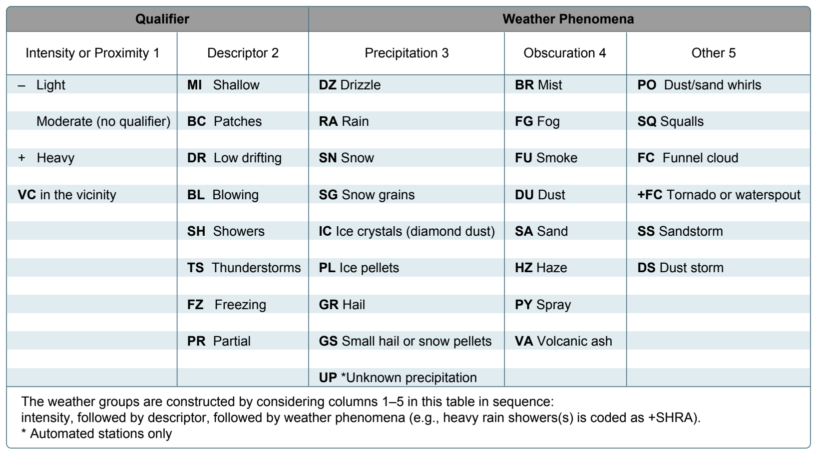
- Weather-can be broken down into two different categories: qualifiers and weather phenomenon (+TSRA BR). First, the qualifiers of intensity, proximity, and the descriptor of the weather are given. The intensity may be light (-), moderate ( ), or heavy (+). Proximity only depicts weather phenomena that are in the airport vicinity. The notation “VC” indicates a specific weather phenomenon is in the vicinity of five to ten miles from the airport. Descriptors are used to describe certain types of precipitation and obscurations. Weather phenomena may be reported as being precipitation, obscurations, and other phenomena, such as squalls or funnel clouds.
Descriptions of weather phenomena as they begin or end and hailstone size are also listed in the “Remarks” sections of the report. [Figure 13-5]
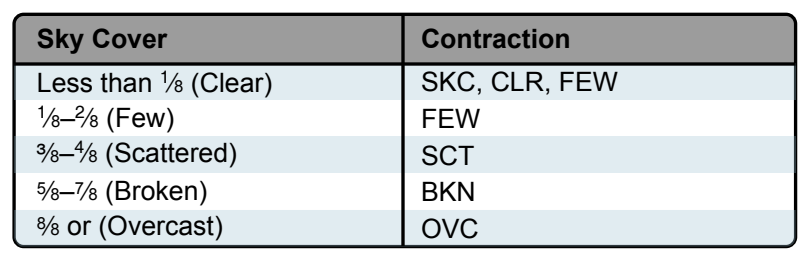
- Sky condition-always reported in the sequence of amount, height, and type or indefinite ceiling/height (vertical visibility) (BKN008 OVC012CB, VV003). The heights of the cloud bases are reported with a three-digit number in hundreds of feet AGL. Clouds above 12,000 feet are not detected or reported by an automated station. The types of clouds, specifically towering cumulus (TCU) or cumulonimbus (CB) clouds, are reported with their height. Contractions are used to describe the amount of cloud coverage and obscuring phenomena. The amount of sky coverage is reported in eighths of the sky from horizon to horizon. [Figure 13-6]
- Temperature and dew point-the air temperature and dew point are always given in degrees Celsius (C) or (18/17). Temperatures below 0 °C are preceded by the letter “M” to indicate minus.
- Altimeter setting-reported as inches of mercury ("Hg) in a four-digit number group (A2970). It is always preceded by the letter “A.” Rising or falling pressure may also be denoted in the “Remarks” sections as “PRESRR” or “PRESFR,” respectively.
- Zulu time-a term used in aviation for UTC, which places the entire world on one time standard.
- Remarks-the remarks section always begins with the letters “RMK.” Comments may or may not appear in this section of the METAR. The information contained in this section may include wind data, variable visibility, beginning and ending times of particular phenomenon, pressure information, and various other information deemed necessary. An example of a remark regarding weather phenomenon that does not fit in any other category would be: OCNL LTGICCG. This translates as occasional lightning in the clouds and from cloud to ground. Automated stations also use the remarks section to indicate the equipment needs maintenance.
Example: METAR KGGG 161753Z AUTO 14021G26KT 3/4SM +TSRA BR BKN008 OVC012CB 18/17 A2970 RMK PRESFR
Explanation: Routine METAR for Gregg County Airport for the 16th day of the month at 1753Z automated source. Winds are 140 at 21 knots gusting to 26. Visibility is ¾ statute mile. Thunderstorms with heavy rain and mist. Ceiling is broken at 800 feet, overcast at 1,200 feet with cumulonimbus clouds. Temperature 18 °C and dew point 17 °C. Barometric pressure is 29.70 "Hg and falling rapidly.
Pilot Weather Reports (PIREPs)
PIREPs provide valuable information regarding the conditions as they actually exist in the air, which cannot be gathered from any other source. Pilots can confirm the height of bases and tops of clouds, locations of wind shear and turbulence, and the location of inflight icing. If the ceiling is below 5,000 feet, or visibility is at or below five miles, ATC facilities are required to solicit PIREPs from pilots in the area. When unexpected weather conditions are encountered, pilots are encouraged to make a report to a FSS or ATC. When a pilot weather report is filed, the ATC facility or FSS adds it to the distribution system to brief other pilots and provide inflight advisories.
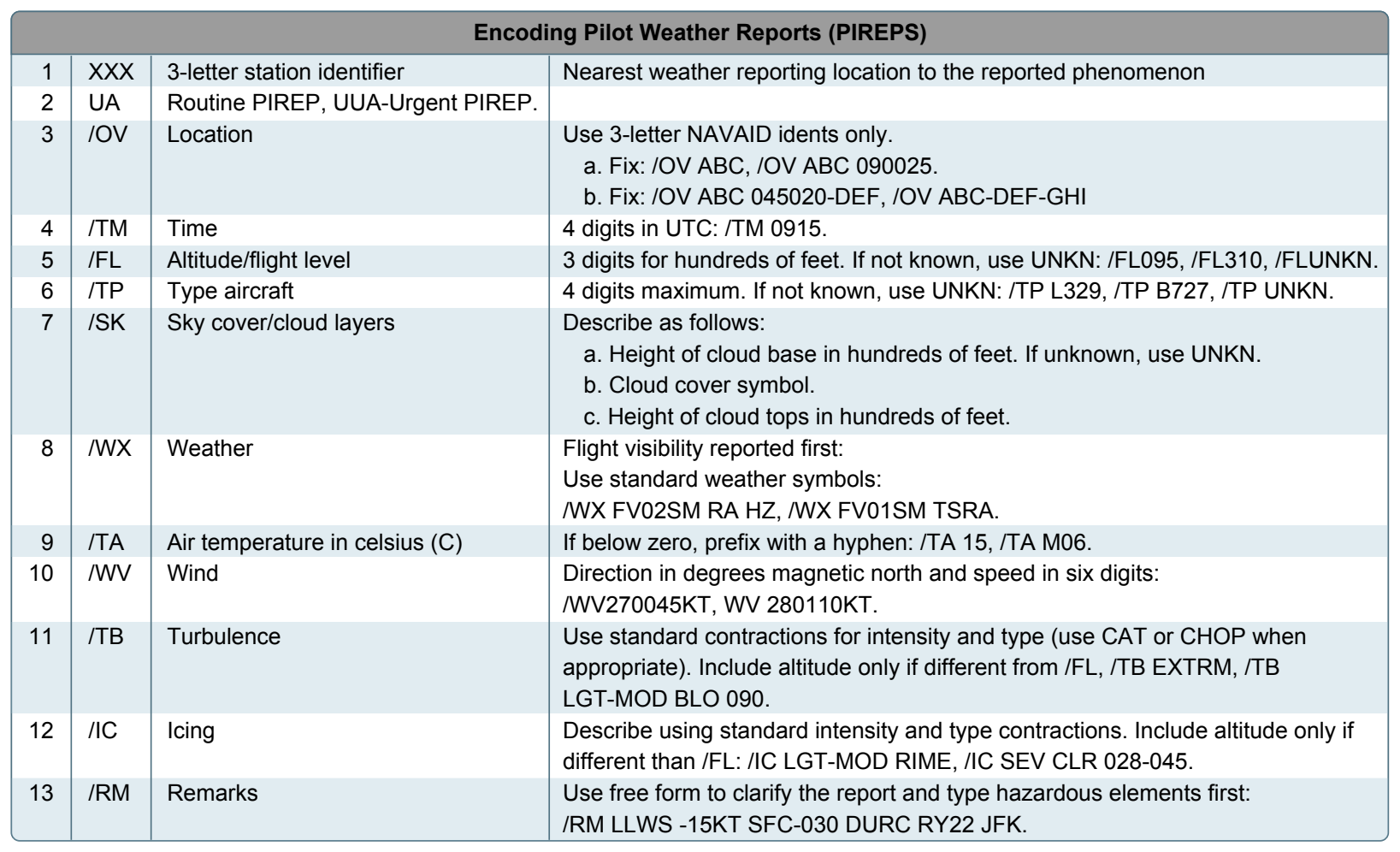
PIREPs are easy to file and a standard reporting form outlines the manner in which they should be filed. Figure 13-7 shows the elements of a PIREP form. Item numbers 1 through 5 are required information when making a report, as well as at least one weather phenomenon encountered. A PIREP is normally transmitted as an individual report but may be appended to a surface report. Pilot reports are easily decoded, and most contractions used in the reports are self-explanatory.
Example: UA/OV GGG 090025/TM 1450/FL 060/TP C182/SK 080 OVC/WX FV04SM RA/TA 05/WV 270030KT/TB LGT/RM HVY RAIN
Explanation: Type:.................................Routine pilot report Location:.......................... 25 NM out on the 090° radial,
Time:................................ 1450 Zulu Altitude or Flight Level: 6,000 feet Aircraft Type:................... Cessna 182 Sky Cover:........................ 8,000 overcast Visibility/Weather:........... 4 miles in rain Temperature:.....................5 °Celsius Wind:................................ 270° at 30 knots Turbulence:.......................Light Icing:................................ None reported Remarks:.......................... Rain is heavy
Aviation Forecasts
Observed weather condition reports are often used in the creation of forecasts for the same area. A variety of different forecast products are produced and designed to be used in the preflight planning stage. The printed forecasts that pilots need to be familiar with are the terminal aerodrome forecast (TAF), aviation area forecast (FA), inflight weather advisories (SIGMET, AIRMET), and the winds and temperatures aloft forecast (FB).
Terminal Aerodrome Forecasts (TAF)
A TAF is a report established for the five statute mile radius around an airport. TAF reports are usually given for larger airports. Each TAF is valid for a 24 or 30-hour time period and is updated four times a day at 0000Z, 0600Z, 1200Z, and 1800Z. The TAF utilizes the same descriptors and abbreviations as used in the METAR report. The TAF includes the following information in sequential order:
- Type of report-a TAF can be either a routine forecast (TAF) or an amended forecast (TAF AMD).
- ICAO station identifier-the station identifier is the same as that used in a METAR.
- Date and time of origin-time and date (081125Z) of TAF origination is given in the six-number code with the first two being the date, the last four being the time. Time is always given in UTC as denoted by the Z following the time block.
- Valid period dates and times-The TAF valid period (0812/0912) follows the date/time of forecast origin group. Scheduled 24 and 30 hour TAFs are issued four times per day, at 0000, 0600, 1200, and 1800Z. The first two digits (08) are the day of the month for the start of the TAF. The next two digits (12) are the starting hour (UTC). 09 is the day of the month for the end of the TAF, and the last two digits (12) are the ending hour (UTC) of the valid period. A forecast period that begins at midnight UTC is annotated as 00. If the end time of a valid period is at midnight UTC, it is annotated as 24. For example, a 00Z TAF issued on the 9th of the month and valid for 24 hours would have a valid period of 0900/0924.
- Forecast wind-the wind direction and speed forecast are coded in a five-digit number group. An example would be 15011KT. The first three digits indicate the direction of the wind in reference to true north. The last two digits state the windspeed in knots appended with “KT.” Like the METAR, winds greater than 99 knots are given in three digits.
- Forecast visibility-given in statute miles and may be in whole numbers or fractions. If the forecast is greater than six miles, it is coded as “P6SM.”
- Forecast significant weather-weather phenomena are coded in the TAF reports in the same format as the METAR.
- Forecast sky condition-given in the same format as the METAR. Only cumulonimbus (CB) clouds are forecast in this portion of the TAF report as opposed to CBs and towering cumulus in the METAR.
- Forecast change group-for any significant weather change forecast to occur during the TAF time period, the expected conditions and time period are included in this group. This information may be shown as from (FM), and temporary (TEMPO). “FM” is used when a rapid and significant change, usually within an hour, is expected. “TEMPO” is used for temporary fluctuations of weather, expected to last less than 1 hour.
- PROB30-a given percentage that describes the probability of thunderstorms and precipitation occurring in the coming hours. This forecast is not used for the first 6 hours of the 24-hour forecast.