
Chapter 13
Aviation Weather Services
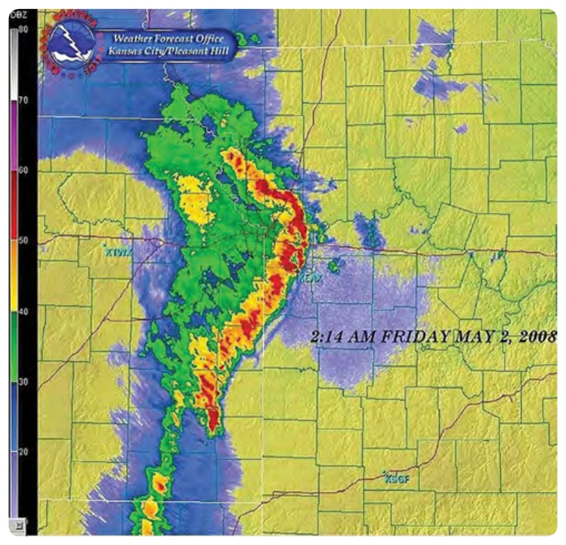
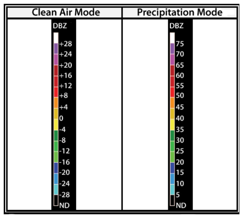
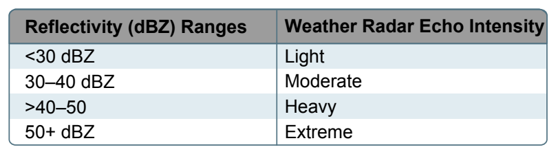
Precipitation targets provide stronger return signals; therefore, the radar is operated in the Precipitation mode when precipitation is present. A faster antenna rotation in this mode allows images to update at a faster rate, approximately every 4 to 6 minutes. Intensity values in both modes are measured in dBZ (decibels of Z) and are depicted in color on the radar image. [Figure 13-1] Intensities are correlated to intensity terminology (phraseology) for ATC purposes. [Figures 13-2 and 13-3]
- FAA terminal Doppler weather radar (TDWR), installed at some major airports around the country, also aids in providing severe weather alerts and warnings to ATC. Terminal radar ensures pilots are aware of wind shear, gust fronts, and heavy precipitation, all of which are dangerous to arriving and departing aircraft.
- The third type of radar commonly used in the detection of precipitation is the FAA airport surveillance radar. This radar is used primarily to detect aircraft, but it also detects the location and intensity of precipitation, which is used to route aircraft traffic around severe weather in an airport environment.
- Airborne radar is equipment carried by aircraft to locate weather disturbances. The airborne radars generally operate in the C or X bands (around 6 GHz or around 10 GHz, respectively) permitting both penetration of heavy precipitation, required for determining the extent of thunderstorms, and sufficient reflection from less intense precipitation.
Satellite
Advancement in satellite technologies has recently allowed for commercial use to include weather uplinks. Through the use of satellite subscription services, individuals are now able to receive satellite transmitted signals that provide near real-time weather information for the North American continent.
Service Outlets
Service outlets are government, government contract, or private facilities that provide aviation weather services. Several different government agencies, including the FAA, National Oceanic and Atmospheric Administration (NOAA), and the NWS work in conjunction with private aviation companies to provide different means of accessing weather information.
Flight Service Station (FSS)
The FSS is the primary source for preflight weather information. A preflight weather briefing from an FSS can be obtained 24 hours a day by calling 1-800-WX BRIEF from anywhere in the United States and Puerto Rico. Telephone numbers for FSS can be found in the Chart Supplement U.S. (formerly Airport/Facility Directory) or in the United States Government section of the telephone book.
The FSS also provides inflight weather briefing services and weather advisories to flights within the FSS area of responsibility.
Telephone Information Briefing Service (TIBS)
The Telephone Information Briefing Service (TIBS), provided by FSS, is a system of automated telephone recordings of meteorological and aeronautical information. TIBS provides area and route briefings, airspace procedures, and special announcements. The recordings are automatically updated as changes occur. It is designed to be a preliminary briefing tool and is not intended to replace a standard briefing from a FSS specialist. The TIBS service can only be accessed by a touchtone phone. The phone numbers for the TIBS service are listed in the Chart Supplement U.S. (formerly Airport/Facility Directory).
Hazardous Inflight Weather Advisory Service (HIWAS)
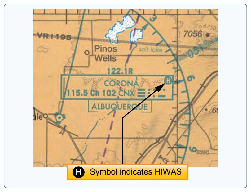
Hazardous Inflight Weather Advisory Service (HIWAS), available in the 48 conterminous states, is an automated continuous broadcast of hazardous weather information over selected VOR navigational aids (NAVAIDs). The broadcasts include advisories such as AIRMETS, SIGMETS, convective SIGMETS, and urgent PIREPs. The broadcasts are automatically updated as changes occur. Pilots should contact a FSS or EFAS for additional information. VORs that have HIWAS capability are depicted on aeronautical charts with an “H” in the upper right corner of the identification box. [Figure 13-4]
Transcribed Weather Broadcast (TWEB) (Alaska Only)
A continuous automated broadcast of meteorological and aeronautical data over selected low or medium frequency (L/ MF) and very high frequency (VHF) omnidirectional range (VOR) NAVAID facilities. The broadcasts are automatically updated as changes occur. The broadcast contains adverse conditions, surface weather observations, PIREPS, and a density altitude statement (if applicable). Recordings may also include a synopsis, winds aloft forecast, en route and terminal forecast data, and radar reports. At selected locations, telephone access to the TWEB has been provided (TEL-TWEB). Telephone numbers for this service are found
in the Alaska Chart Supplement U.S. (formerly Airport/ Facility Directory). These broadcasts are made available primarily for preflight and inflight planning, and as such, should not be considered as a substitute for specialist-provided preflight briefings.