
Chapter 16
Navigation
- The angle at which the aircraft is flown toward a desired course (angle of intercept)
- True airspeed and wind (GS)
- Distance from the station
Angle of Intercept
The angle of intercept is the angle between the heading of the aircraft (intercept heading) and the desired course. Controlling this angle by selection/adjustment of the intercept heading is the easiest and most effective way to control course interceptions. Angle of intercept must be greater than the degrees from course, but should not exceed 90°. Within this limit, make adjustments as needed, to achieve the most desirable rate of intercept.
When selecting an intercept heading, the key factor is the relationship between distance from the station and degrees from the course. Each degree, or radial, is 1 NM wide at a distance of 60 NM from the station. Width increases or decreases in proportion to the 60 NM distance. For example, 1 degree is 2 NM wide at 120 NM-and ½ NM wide at 30 NM. For a given GS and angle of intercept, the resultant rate of intercept varies according to the distance from the station. When selecting an intercept heading to form an angle of intercept, consider the following factors:
- Degrees from course
- Distance from the station
- True airspeed and wind (GS)
Distance Measuring Equipment (DME)
Distance measuring equipment (DME) consists of an ultra high frequency (UHF) navigational aid with VOR/DMEs and VORTACs. It measures, in NM, the slant range distance of an aircraft from a VOR/DME or VORTAC (both hereafter referred to as a VORTAC). Although DME equipment is very popular, not all aircraft are DME equipped.
To utilize DME, the pilot should select, tune, and identify a VORTAC, as previously described. The DME receiver, utilizing what is called a “paired frequency” concept, automatically selects and tunes the UHF DME frequency associated with the VHF VORTAC frequency selected by the pilot. This process is entirely transparent to the pilot. After a brief pause, the DME display shows the slant range distance to or from the VORTAC. Slant range distance is the direct distance between the aircraft and the VORTAC and is therefore affected by aircraft altitude. (Station passage directly over a VORTAC from an altitude of 6,076 feet AGL would show approximately 1.0 NM on the DME.) DME is a very useful adjunct to VOR navigation. A VOR radial alone merely gives line of position information. With DME, a pilot may precisely locate the aircraft on a given line (radial).
Most DME receivers also provide GS and time-to-station modes of operation. The GS is displayed in knots (NMPH). The time-to-station mode displays the minutes remaining to VORTAC station passage, predicated upon the present GS. GS and time-to-station information is only accurate when tracking directly to or from a VORTAC. DME receivers typically need a minute or two of stabilized flight directly to or from a VORTAC before displaying accurate GS or time-to-station information.
Some DME installations have a hold feature that permits a DME signal to be retained from one VORTAC while the course indicator displays course deviation information from an ILS or another VORTAC.
VOR/DME RNAV
Area navigation (RNAV) permits electronic course guidance on any direct route between points established by the pilot. While RNAV is a generic term that applies to a variety of NAVAIDS, such as GPS and others, this section deals with VOR/DME-based RNAV. VOR/DME RNAV is not a separate ground-based NAVAID, but a method of navigation using VOR/DME and VORTAC signals specially processed by the aircraft’s RNAV computer. [Figure 16-35]
NOTE: In this section, the term “VORTAC” also includes VOR/DME NAVAIDs.
In its simplest form, VOR/DME RNAV allows the pilot to electronically move VORTACs around to more convenient locations. Once electronically relocated, they are referred to as waypoints. These waypoints are described as a combination of a selected radial and distance within the service volume of the VORTAC to be used. These waypoints allow a straight course to be flown between almost any origin and destination, without regard to the orientation of VORTACs or the existence of airways.
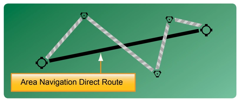
While the capabilities and methods of operation of VOR/ DME RNAV units differ, there are basic principles of operation that are common to all. Pilots are urged to study the manufacturer’s operating guide and receive instruction prior to the use of VOR/DME RNAV or any unfamiliar navigational system. Operational information and limitations should also be sought from placards and the supplement section of the AFM/POH.
VOR/DME-based RNAV units operate in at least three modes: VOR, en route, and approach. A fourth mode, VOR Parallel, may also be found on some models. The units need both VOR and DME signals to operate in any RNAV mode. If the NAVAID selected is a VOR without DME, RNAV mode will not function.
In the VOR (or non-RNAV) mode, the unit simply functions as a VOR receiver with DME capability. [Figure 16-36] The unit’s display on the VOR indicator is conventional in all respects. For operation on established airways or any other ordinary VOR navigation, the VOR mode is used.
To utilize the unit’s RNAV capability, the pilot selects and establishes a waypoint or a series of waypoints to define a course. A VORTAC (or VOR/DME) needs to be selected as a NAVAID, since both radial and distance signals are available from these stations. To establish a waypoint, a point somewhere within the service range of a VORTAC is defined on the basis of radial and distance. Once the waypoint is entered into the unit and the RNAV en route mode is selected, the CDI displays course guidance to the waypoint, not the original VORTAC. DME also displays distance to the waypoint. Many units have the capability to store several waypoints, allowing them to be programmed prior to flight, if desired, and called up in flight.
RNAV waypoints are entered into the unit in magnetic bearings (radials) of degrees and tenths (i.e., 275.5°) and distances in NM and tenths (i.e., 25.2 NM). When plotting RNAV waypoints on an aeronautical chart, pilots find it